Monday, October 13, 2008

Goosenecks State Park, UT and Monument Valley, AZ

Gooseneck State Park is located on top of a bluff overlooking the San Juan (I think) River. It winds in such a way from looking down it looks like a gooseneck. There are actually 3 of these goosenecks visable from top of the bluff. We were only there one night since we decided to go on a guided tour of Monument Valley the next day.

 
The Gooseneck.

Here I am with John Wayne.


This is as picture post card perfect as you can get of Monument Valley.


Monument Valley is on the Navajo Reservation and access is limited unless you go on their guided tours. Monument Valley is famous for the many films and movies which have been made in this area, especially those with John Wayne and many other western movies. There was a museum which had info on the many movies made in this area.

Moab, UT

I fell in love with Moab and all the things to do there. We were parked right on the Colorado River and right across the street was a 1 1/2 mile hike to Corona Arch. Down the road was Arches National Park where we hiked to Delicate Arch and took a ranger led hike through the Fiery Furnace. Also, close by was Canyonlands National Park Island in the Sky. We 4-wheeled to Island in the Sky, hiked around and 4-wheeled home. My favorite place though was a stop we made on our 4-wheel trip up to Island in the Sky.

 
 Here I am overlooking the canyon which was breath taking. No photo will ever do it justice.
  I haven't seen Grand Canyon yet, but this view was awesome. I can't imagine anything prettier.

Another 4-wheel trip was to Gemini Bridges. We first 4-wheeled to the bottom of the canyon, yet went out and 4-wheeled to the top. Here we are at the bottom of the canyon.


This is Corona Arch, just 1 1/2 mi hike across from our camping area. We got up early one morning to catch sunrise.

And here I am standing in front of one arch which overlooks Delicate Arch in Arches National Park.


Here Max had to carry Fancy up the ridge. It was a little steep for her little short legs.
Here I am on the ranger led hike through Fiery Furnace. We were hiking through slots where you had to turn sideways to get through.
This was at Canyonlands Island in the Sky, Mesa Arch. Just on the other side is a sheer drop off, but it is probably 10 feet wide across the top. Some were brave enough to venture out onto the arch.


Grand Junction

There was so much activity while in Grand Junction, I cannot begin to post enough pictures, so I will tell you and post only a few pictures. We hiked the Monument Trail in Colorado National Monument. It was about a 6 mile hike from the top down to the bottom on the canyon. We had 21 people make the hike. And we even had some excitement when one of the hikers hurt their knee and we had to call 911 and she was evac'd down the last mile or so. But other than a few blisters and some sprained muscles, she was ok. I was up ahead and decided to play a joke a few of my fellow hikers, so I climbed over the side of the slope and hung on like I was falling off. And of course someone got my picture. There was also a rock called Inscription Rock which was supposed to have some writing about 100 years old. We found the rock and climbed it, but couldn't really make out what the writing said.

Here we are on top of Inscription rock.

And here I am over the cliff. It is a long ways down to the bottom.
One day we hiked to a Mica Mine.

One day we hiked to Marble, CO, where of course they mine marble. In fact the marble for the Jefferson Memorial came from Marble, CO. Here I am with Max, lounging on a huge slab of marble.
Outside of Marble is a 4-wheel drive road to Crystal Mills. Here I am in front of the old mill. Just 1/4 mile further is the town of Crystal Mills. During the summer there are actually people to live there. They take the 4 mile 4-wheel drive road down to town every few weeks. It takes about 2-3 hours to go the 4 miles.

 We kayaked the Colorado river right through town, yet seldom saw any signs of civilization, except for some signs such as this tree house.

We kayaked both the Gunnison and the Colorado River. On the Gunnison River I took my first spill in the kayak. I hung on for almost 1/4 mile before I found a place I could manuever to the side and get out. It was cold. There were a total of 4 of us who dumped that trip at the same spot. We were going over a 2 foot waterfall. I guess I was having so much fun I forgot to pay attention to what I was doing. It turned out to be an expensive kayak trip since I lost my glasses and had buy new ones to see. I also lost some clothes and other articles which were just laying in the floor of my kayak. Lessons learned. Above is a picture of a tree house on the Colorado river.
We also biked along the Colorado River in Grand Junction.

I believe we had over 40 people attending this gathering and had lots of fun. We went to a Mexican Restaurant one evening and went dancing at the Moose Lodge on our last night.

El Jebel

As we got closer to Grand Junction, we realized we were early, so we stopped at El Jebel, which was actually the first stop for CUACK (Colorado, Utah, Arizona, California Kayaking). We were several days late, so missed some of the activities such as biking to Aspen, but we did get there in time for the bowling tournament, which I won the high scoring game of 162. We also did some 4 wheeling when we went to Marble, CO, and Crystal Mill, and we visited a ghost town. We did go into Aspen during their farmers market and had to buy several items. I purchased a huge chocolate tort, which was wonderful.

 
Even in a ghost town I find myself drawn to the saloons.

Here I am throwing my winning bowling ball.

Wyoming

After leaving SD, I headed towards Grand Junction, CO. Of course I had to travel through WY. Since Max had not seen Ft. Laramie, the Oregon Trail Ruts or Register Cliff, we stopped for a few nights at the town park of Ft. Laramie. No hookups, but the little park was quiet and asked only for a donation. Of course we went into town for dinner one night and found the only restaurant available.

On our way back from the actual old Fort, I saw this sign and couldn't resist.

I always wondered just who they were talking about.

I posted pictures of the Oregon Trail Ruts and Register cliff back in my June blog, so I'm not posting more pictures this time.

After leaving WY, we headed towards Denver, stopping on the way to tour the Budweiser brewery. Our tour guide was the daughter of the head brewmaster, so she has been raised around the Budweiser breweries all her life. She was a great guide. Got to try several new beers but decided I didn't like any of them.

Left Ft. Collins and the brewery and headed into Denver. Parked overnight behind a Sam's Club and then met my kids and grandson, Brian, Donna and Joshua at the Old Chicago Pizzaria in Aurora about 9pm. Had a nice, but short, visit.

Next day we headed across the Rockies towards Grand Junction.....

Rapid City Area

Leaving Theodore Roosevelt National Park, we headed south and stopped at Belle Fourche for several nights, parking at the Moose Lodge. While there we found out it is considered to be the geological center of the US, including Alaska. They have lots of info and a placque at the visitor center, but the actual survey marker is about 15 miles north of town in a field which is private property.

 
Here I am standing on the marker at the visitor center, where I supposed to be standing in the center of the U.S.
We also took a day trip over to Devil's Tower. It was just as spectacular as all the pictures ever showed.


Here are some climbers on the side of Devil's Tower.


On our way to Devil's Tower we came across an old mining town. This is the original general store which is over 100 years old. It is now the post office, the liquor store and still a general store.


And of course we had to stop in Deadwood while in the area. And if you are in Deadwood you have to go to Saloon No. 10 where Wild Bill Hickock was killed. Here I am standing with him before he reenaced his death.


We also visited some mined in Lead (pronounced Leed), and moved down to a National Forest Campground called Alkali campground, outside Sturgis. From there we visited Fort Meade. It is still an active Army Guard base, but was originally a cavalry base. It still has lots of original buildings. We didn't get to go in the museum as it was closed because of school field trips.

Theodore Roosevelt National Park

Again, I am playing catch up. I was in Theodore Roosevelt National Park early September, and here it is October and I am just now posting about it. But I finally got to visit and spend some time in North Dakota. We spent several days at the park, hiking and sightseeing the area. Theodore Roosevelt loved this area and had a cabin and eventually a ranch here. He like to hunt and that was the reason for wanting to preserve this area, hence the national park. There is still a large herd of wild horses in the park as well as bison and elk, but we only saw the bison and horses.

 
Wild horses froliking in the road

Looking down on the Little Missouri River. It also ran along side the campground. Notice the coat and earmuffs. It was cool.


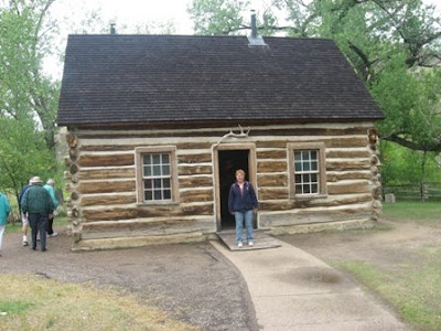
Here I am in front of Teddy Roosevelt's cabin. It has been restored and has much of his personal items in the cabin.


I just had to post this picture. They call it 'scoria' and have some fancy explanation about it's makeup, but for all I could see, it's just plain old red sandstone like you find in Oklahoma.


Friday, September 12, 2008

Kayaking the Missouri River

After leaving Minnesota, we headed west to North Dakota, specifically we were headed to Theodore Roosevelt's National Park on the west side of ND. But along the way, we stopped for several nights at Washburn, ND. We had a great parking spot at the city park, right on the Missouri River. The park sign said we needed a permit (free), but you could only get the permit during work hours, 8-5 and Mon-Fri. We arrived on Saturday. Also at Washburn was the Lewis and Clark Interpretive Center and there they said the police patrolled the park and we really needed the permit. So we were planning on moving on down the road until we went across the road to the gas station. In a casual conversation with the clerk, they were so nice, they contacted the police department for us and let them know we were going to be at the park. So we were not harrassed and yes the police did patrol the area regularly. Only on Sunday afternoon was anyone else using the park. While there we wanted to visit the Lewis and Clark Interpretive Center and Fort Mandan. Fort Mandan was a fort, not a military fort, but the fort built for Lewis and Clark to spend one winter, in 1805. When they returned in 1806 the fort had flooded and burned. It has been restored upriver from its original location. The fort was one of the most interesting since it was so small. Built in the shape of an A, it only had 10 rooms, five on each side and a small area in the middle. The interpretive center was very good. It had Lewis and Clark's travels from their beginnings through the end. They even had info on all the people who traveled with them. Quite interesting. But of course, we also decided to kayak the Missouri River. It was only 9 miles down to a state park. We shuttled cars and then put in our kayaks at the park. It wasn't too bad when we started, a little headwind, and the current on the river is not much at all. There were lots of sandbars and logs in the river, but no problem for us in our kayaks. Until, the wind picked up. As we continued the wind kept getting stronger. Before long if we didn't keep paddling the wind would push up back upstream (later we found out the winds were blowing up to 40 mph). We did find some small rapids, but even there we had to paddle hard to keep from going backwards. At mile 7 we saw the campgrounds for the state park. We pulled out and Max walked the final 2 miles down to the jeep and came back to pickup the kayaks. While on his walk to the jeep he saw waves on the river that were several feet high. We were glad we took out when we did. It was at the visitor's center at the state park where we found out the winds were 40 mph and the park (which usually rents and shuttles kayakers and canoers) wouldn't put anyone on the river that day. But we survived and can now say we have kayaked the Missouri River.

 
This is where we took out 7 miles down river.

Our campsite on the Missouri River in a Washburn city park.
Here is where we put in our kayaks in Washburn, MN, on the Missouri River


Inside one of the room at Fort Mandan. Up to 7 people would sleep here.


In front of the Lewis and Clark Interpretive Center.


Headwaters of the Mississippi

While staying at Fosston, MN, we took a day trip to find the headwaters of the Mississippi River. We knew to go to Lake Itasca, which was about 35 miles away. Once there we found a pretty lake which has been designated as the place where the Mississippi River starts. Over the years there have been several other locations, but Lake Itasca was finally the where it was placed. At the headwaters the river is very shallow and not very large. We waded across easily. We also took a drive around the wildlife loop and hiked and climbed to the fire tower. What a great view. Here are a few pictures from our trip.

 
Here is the lodge.

Just to prove I was really there.


Here I am standing in the headwaters of the Mississippi River.


The firetower.


Lake of the Woods

Boy, did I get behind in my updates quickly. I am currently in Jebel, CO, and I have lots to post, but, I will continue with my travels from International Falls. On west towards Lake of the Woods and the Northwest Angle. Trivia Question: Where is the most northerly spot in the continental U.S.? No, it is not Maine or Washington, it is Minnesota, specifically, the Northwest Angle. In fact, to reach this spot of the U.S., you must travel by boat on Lake of the Woods or travel by vehicle through Canada. Yes, you read correctly, Northwest Angle is not connected by land to the rest of the U.S. It consists of a series of islands and a peninsula of Manitoba. We stayed in Warroad, MN, at a Moose Lodge for 2 nights, visiting Northwest Angle and the local town. Warroad is the home of Marvin Windows and Doors where we went to there museum. Then on to Roseaou, MN, where they had the nicest camping in the city park. Here we stayed while we toured the Polaris factory and museum. We were fascinated and decided to head south 60 miles to Thief River Falls to tour the Artic Cat factory. I personally was more impressed with Polaris. Below are a few pictures of our travels. Notice the first picture. Going into and out of Northwest Angle they don't even have manned customs, instead you phone in with a video phone (I didn't know they really existed).

 
Where we called to clear customs.

Here I am leaving Manitoba entering Northwest Angle.


We visted several ATV/snowmobile plants.  Here we are at Artic Cat

And here we are at Polaris.