Saturday, June 30, 2012

El Jebel

My leg is still in a splint, so my participation in things is limited, so I'll show you a little of what I have been able to do, and some of what I've missed.

There are 30+ RVs parked in a lot behind the park 'n ride for the bus stop.  The bus service is good  here, and this makes it very convenient for many of our activities.

About 2 blocks away is where we have been congregating in the late afternoons for happy hour.  Besides the $1 drinks, they have great food.

Our group sort of takes over the place, but we sure have lots of fun.

One day the group visited Maroon Bells, said to be one of the most photographed mountains in Colorado.
The Maroon Bells are in the background, as is Maroon Lake.
About 20+ came up for the trip, and just about everyone hiked either back to the source of Maroon Lake, which was a waterfall, or they hiked up to Crater Lake, about 1.5 miles further up the mountain.  I brought a book and sat down by the lake and read and enjoyed the wonderful scenery.

ou
The Maroon Bells without us cluttering up the scenery.  

You can easily identify the avalanche areas.
The only way to get to Maroon Bells is by bus.  You can drive to Aspen Highlands, but even from there it is an 8 mile bus ride.  The drivers provide a narrative of the history of the area, along with much geographical information.  I thought the bus ride was well worth the trip, the scenery was just the icing on the cake.

Yellow-bellied marmots are quite common in the area, and this young one even posed for me.

On the bus ride back we have the "hear no evil, speak no evil and see no evil".

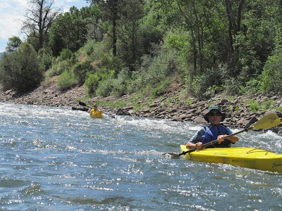
Now for some of what I didn't get to do, kayaking down the Roaring Fork River.

There were about 24 kayaks that started, but 2 flipped over immediately, and one of those decided not to kayak on this particular day.

The outfitters and locals had indicated the river was low and would probably not be real exciting, and there would be lots of portaging over the rocks.  Well, that wasn't what the group found.  It was six miles of fast water, with only about 100 feet of slow moving water, and many class 2, and someone was told later, even a class 3 rapid along the route.

Out of the 20+ who started only 6 made it down the entire trip without ending up like this.  And some ended up like this several times.

Even if you kept the right side up, the waves splashed into the kayaks and everyone had to stop and bail water.  Usually our water guns are for water fights on the river, but they also do double duty for bailing the water out of the kayaks.
And a note, 7 of the ladies decided about half-way down, they were ready to quit.  So they hauled their kayaks up the bank and left them there to be picked up later.  Marvin had taken gps coordinates, so he knew where to return for them.  The ladies then walked about a mile to the Walmart and the bus stop, where they caught the bus and arrived back at camp only about 30 minutes before the rest of the kayakers.

The group who kayaked the entire 6 miles.

Later in the evening was a concert at the base of Snowmass Mountain.

Firefall was the band.  Originally from the Boulder area back in the 1970s, their biggest hit was  "You are the Woman".  It was too bad it got rained out and had to end early, it was a great concert.

My next blog will be on Marble and the Crystal Mill.

The last of Grand Junction

Peggy held a photo contest and I won in the landscape category.  It was my picture of the Lower Calf Creek Falls, taken back while I was staying at Torrey, UT. 
Lower Calf Creek Falls is located in the Grand Staircase of the Escalante.  My prize?  A box of chocolates.  Max won in the category of people and action, and Diana won for the best flower photo.  I don't have a copy of Max's photo, he made a collage of several of the activities.  You can see Diana's photo at her blog:

A few days before I went back to the doctor and he put me in the splint, I thought I was getting better and the bike ride would be theraputic for my knee.  So I did a 10 mile bike ride along the Colorado River.  (I guess it wasn't as theraputic as I thought)

Getting ready for the ride.

They have a wonderful bike trail on both side of the river.

This is my favorite part of the ride.  It is about 4 miles through this shaded forest area along the river.


Friday, June 22, 2012

When it rains, it pours......

For the past month I have been hobbling around with a gimpy leg.  How did it get this way?  Well, first, while visiting my grandson, I stepped out of his jeep (which has a lift kit on it making it way high) and ended up doing the splits with one leg on the ground and the other still in the jeep.  Ouch.  It was sore but didn't hurt much when I walked, so I continued my morning walks with Fancy, and when I arrived at Capitol Reef National Park, I did several hikes.
But then I went dancing.  What a mistake.  Those spins and twirls on an already sore leg, wasn't a good thing.  Next morning I headed towards the nearest clinic.  They x-rayed both hips and knee, and thankfully there was no fracture.  I was told to be careful, use some crutches, and they gave me some medicine.  So I went back and borrowed a crutch and used it for maybe 2 days, then went back to my regular routine.  
Well, it's been 2 weeks since I visited the doctor and I'm not much better.  Some days I can barely walk.  So yesterday I purchased some crutches and I'm finally doing what the doctor told me several weeks ago.     If I'm not better by next week, then it's back to the doctor again.  If nothing else, this has given me a new compassion for people with chronic knee and back problems.
My grandson's jeep, which I fell out of.

And while I was here in Grand Junction I decided to have the tires on my car rotated.  I mean, it's only been 2 years since it was last done.   Well, the inside of the front tires were worn down to the steel belts.  Not good.  So 4 new tires.  But the good news was I got a pro-rated price on the tires because of the warranty.  So on I go to have the front end alignment, which I thought was going to be a simple job, but that was not the case.  A nut had come loose and wallowed out something under there and now I require a new ball joint and several other pieces.  So, even though it's been an expensive week with car repairs, it's nothing to what it would have cost me if the front end had fallen apart or if my front tires had blown out while towing. 

I sure hope next week gets better.  I can take only so much drama. 


Wednesday, June 20, 2012

Grand Junction-Grand Mesa and a Rodeo

I had never been on the Grand Mesa, so we took a day trip to see the sights.  Grand Mesa is the largest mesa in the U.S., over 500 miles at 10,000 feet.  When we left Grand Junction it was in the high 90s and was supposed to get to 100 degrees today.  Here on the Mesa it was in the 60s.

We even found snow.

Raber Cow Camp was located on the Grand Mesa.  In 1861, homesteaders rushed into the Colorado territory.  For the next 70 years, cattle was herded to the mesa during the summer, then brought back down for the winter.  Cow Camps, like this, were provided for the cow hands and sometimes even their families, while they were watching the cattle.  

The Mesa has hundreds of small ponds and lakes.  Moose have been relocated to Grand Mesa and there is now a herd of about 350.  But, we didn't see any.

There is a prominence on the Grand Mesa called Lands End.  It overlooks Grand Junction and the entire valley.  We are hoping to come back later in the week and take the squiggly road you see.  It is 18 miles down to the valley, instead of the 50+ miles it took to get up by highway.

At Lands End the chipmunks are friendly and curious.  Here, Fancy is just as curious as the chipmunk.

In nearby Fruita they have a rodeo every Tuesday night during the summer months.  They always start with the mutton busting.  Here the little tykes get to get some experience riding the wild sheep.

The official start is the grand parade, where all participants come out for a presentation of the flags, prayers and the National Anthem.

Only 2 riders made it the entire 8 seconds tonight.

They weren't having much luck with calf roping either.
It was a fun evening.  Many of the participants were young, in their teens, getting experience and points for gaining entrance into the pro rodeo circuit.  

Moab, UT-Gold Bar Campground

On the way to Moab from Capital Reef, we stopped at the Hanksville-Burbee Dinosaur Quarry.  It was an 8 mile 4-wheel drive road into the quarry.  I felt like I was in the beginning scene of Jurassic Park.

This is the quarry location.  Some are staff from the Burbee Museum of Natural History in Rockford, IL.  Others are interns on their first dig.

They use some air tools, but lots of hard work and sweat too.

Some of the interns.

They haven't really started to work on this specimen yet.  Once a specimen is ready to be removed, they cover it with plaster, then remove it.  The plaster helps keep it from crumbling or breaking during removal.

The staff stay in town, driving the long 10 miles each way daily out to the site.  The dinosaur remains are taken out and shipped back to the Burbee Museum for restoration and study.   Brushy Basin in the Morrison Formation is a large site, comparable to the largest site in the Morrison Formation.  It has the fossilized bones of multiple Late Jurrasic dinosaurs.

On our way out we spotted this building.  It looks like some sort of biosphere,complete with air locks.  It is the Mars Desert Research Station.  Click on the link for more info, but in short, this is the second of four  habitats built for simulating Mars surface exploration.
 Moab was hot and we were boondocking with no hookups right on the Colorado River.  Because it was so hot, we didn't do as much hiking as normal.  Some did hike in Arches National Park, but we found other ways to keep cool.
In Moab, we had the opportunity to kayak.  Our first kayak was from our campground  down to Potash, about 10 miles downstream.  The water was very low and it was flat water.

The scenery was great though.  Since it was so hot, we had lots of water fights, too.

Some of us did a 4-wheel drive trip from Moab to Canyonlands National Park.  This is one of my favorite views.

The 4-wheel group.  Actually, no one really needed 4-wheel, but it was definitely high clearance.

It's always fun to drive through a hole left by a fallen boulder.

This is Gemini Bridges, a double arch.

From Canyonlands, we took this winding road 7 miles down to the valley.   The drop was over 2400 feet in less than 3 miles.  Pretty steep, but lots of fun.

We took a 2nd kayak on the upper stretch of the Colorado River which was supposed to have 9 Class I/Class 2+ rapids in about 10 miles.

We were not disappointed.  Everyone had a great time.

Even those who didn't keep the open side up.

We also had time for water gun fights.

But we also spent lots of time bailing the water out of our kayaks after each set of rapids.

Our kayaking group.

This was me going through Rocky Rapids.  Luckily I managed to keep the open side up at all times.

Sunday, June 10, 2012

Lower Calf Creek Falls-Grand Staircase-Escalante NM

Lower Calf Creek Falls is in the Grand Staircase-Escalante National Monument, about 47 miles south of where we were staying.  But the drive on Highway 12 was great.
I found this window to peek through at the start of the hike.  The hike was 3 miles one way, but it ended at a 126 ft waterfall.
There was lots of cactus blooming.  In the early morning the blooms were not completely open.

Calf Creek ran along the bottom of the canyon.  With the water there were lots of trees and grass.  At one time, people settled in this area and grew watermelons and kept their calves in the canyon.  Hence the name, calf creek.

Not the largest waterfall I've been to, but still very beautiful.  And the water was cold.  Too cold for me to get wet.

The mist from the waterfall keeps the surrounding canyon walls wet, allowing the ferns to grow, seemingly, right out of the canyon walls.

The hikers.

On the way back the cactus had opened its blooms.

We spotted several beaver dams like this one, but never caught sight of the beavers.

These are pictographs, not petroglyphs.  The difference is pictographs are painted images on the rocks, while petroglyphs are etched into the stone.  They say these are from the Fremont Indian duration, thousands of years ago.

Between Capitol Reef and Grand Staircase-Escalante is the Dixie National Forest.  The way some of the trees stick up higher makes me think of the African Savannah.

I always love forests, but I think the contrast of the forest and the surrounding rock canyons made me appreciate the forest even more.

Heading south on Hwy 12 we saw signs for 14% grades, and coming back the highest was 10%.  Regardless, I don't plan on taking my RV on that stretch of highway.