Saturday, July 12, 2008

St. Ignace

The next location was St. Ignace, MI, still on the upper peninsula, but at the northern end of the Mackinac (pronounced Mackinaw) Bridge. The Mackinac Bridge is the 3rd largest suspension bridge in the world (at least they claim) and connects upper Michigan (yoopers) and lower Michigan (trolls). We found lots to do while in the area. Staying at the Moose Lodge outside of town was a great base for visiting the various historical sites such as forts and lighthouses, Mackinac Island, and of course kayaking.

Parked out behind the Moose Lodge.


St. Ignace was originally founded by Father Marquette, a Spanish Jesuit Monk, in 1671. It was later abandoned and moved, but Father Marquette is credited with mapping most of the Michigan and great lakes area, clear down to the Arkansas river.


One day was spent exploring Fort Michilimackinac, built in 1715.

I'm not going to try and pronounce it.


And several times each day they fire the cannon at the end of the interpretive tour.


Of course there was the Lighthouse next door.


Another day we took a boat out to Mackinac Island. One the way we went over to the Mackinac Suspension Bridge which is 5 miles long.


Once at the island we had to see Fort Mackinac. This fort was moved from Fort Michilimackinac in about 1769, then Fort Michilimackinac was burned to the ground. The British had taken Ft. Michilimackinac from the Spanish and now that the Revolutionary War was going on the British didn't want the American revolutionaries to take the fort. And again, they fire the cannon at Ft. Mackinac throughout the day.


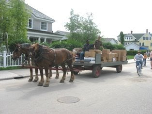
But by far the best part of the day was going to the Grand Hotel. It was built by John Jacob Astor who made his fortune in fur trading. Even in the early 1800s it was a posh place to go. Eventually the hotel became the resort play ground for the rich and famous of the late 1800s. Mackinac Island allows no motorized vehicles except for the Police Chief, Fire Chief and Doctor. Everyone else either rides a horse, a bike or walks. This carriage is how you would be picked up at the dock if you were staying at the Grand Hotel.
This is looking at the hotel from the road.


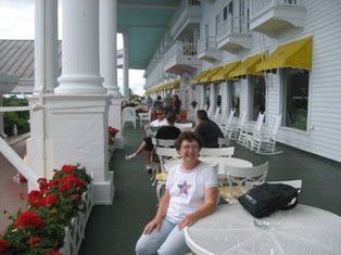
They don't allow tourists to walk in and around the grounds unless you pay $15. Somehow we walked in and was never asked to pay. So we went upstairs to the outdoor terrace and had a drink.


Even UPS doesn't get to drive their brown truck. Here is the UPS man collecting and delivering on the island.


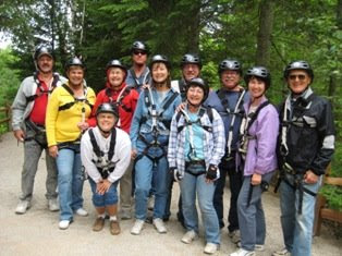
Another fun place was Historic Mill Creek Discovery Park. The park has restored an old water powered saw mill from the late 1700s and early 1800s. But in addition they have added some fun things to do, such as zip lines, climbing walls and canopy bridges. Here is the group who tackled these challenges.


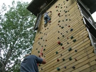
First for some of us was the climbing wall. Yes, that is me up there. I made it all the way.

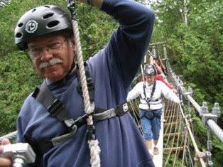
Next was the canopy bridge. I turned around and took this picture of the rest of the group. We were 50 feet above the creek. There was only a small plank on the suspension bridge, but we were tethered to ropes suspended above us.


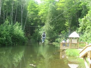
And finally, the zip line. It was 452 feet and took about 25 seconds to go down. Yes, everyone, I zipped down the line. It wasn't quite the thrill of jumping out of an airplane, but it was fun.


Our last day was a 9 mile kayak trip on the Carp River. The river ran into Lake Huron, but the wind was driving the waves such that we couldn't paddle out to the lake. The mosquitoes were quite bad. They've been bad anyway, but on the river they were terrible. With my hat and netting I wasn't having too much trouble, but that might have been because of the can of bug spray I also had on.


This was one of the most challenging and interesting paddles for me yet. We ran into many obstacles. This first obstacle most of us had to get out of the kayak and lift it over the logs blocking the river.


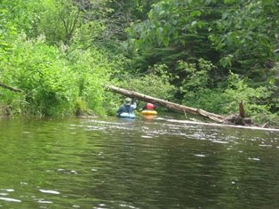
But we also had limbo logs to go under too.


And some were just maneuvering in and out of the trees.
  Then we either had calm water where it felt like I was paddling in pea soup, or shallow rapids where you were busy dodging the rocks in the river.


But then it was the end of the gathering. The group went to the fish fry at the Moose Lodge, then dancing at the Kewadin Casino. But the dancing was short lived since the band didn't do much country, was way too loud and way too much rock and roll. Tomorrow is travel day to Sault Saint Marie, Ontario, Canada.

Sunday, July 6, 2008

In Between

Between gatherings some of us stopped off to see more sights. There was an abandoned airfield which turned out to be a great place to park for a few nights. We even got to see some windsurfers out on the runway. The airfield is now owned by the National Forest Service and leased to GM and Ford for vehicle testing in the winter. But in the summer it stand vacant. The locals come out on the weekends to 4-wheel, windsurf and sometimes even drag race. But the history is even better. It was built years ago by the military and was used to store nuclear weapons in bunkers and the runway was designed for the large airplanes, like a B-52, to land and take off. No military base, just the runway and bunkers. But the runway is triangular, 2 miles x 2 miles x 2 miles. Large enough so it can be an alternate landing site for the space shuttle.


Some additional sights seen in this in between stop were:


Tahquamonen Falls had both an upper and lower falls and many trails. The property was originally privately owned, but in the 1940s was entrusted to the state of Michigan with the clause it had to be used for the people otherwise ownership would revert to his heirs. It is now a state park.

Lower Falls

Upper Falls. This is supposed to be the 2nd largest falls east of the Mississippi. It has a 50 ft drop and is over 200 feet wide.


Friday, July 4, 2008

July 4

On the way to town for the 4th of July parade and festivities, several of us went geocached. And what is geocaching you ask? Well, I didn't know either. Basically, it's a current day, world wide scavenger hunt. From the http://www.geocaching.com/ website you can put in the closet zip code to where you are and it will give you a listing of geocache sites. You then print out this information and try to find the geocache. Once found, you sign the log book and can then take something if you leave something. 
Here was the first find of the day. We found 2 that morning.


But then it was time to get to town for the parade. Here are just of few of the highlights from the day.
Waiting for the Parade to start.


And yes those are real chickens, pooping on the table. It is chicken poop bingo.

One of our group entered their dog in the Pet Parade.

But the best of the day was the firefighters water fight.


Ending the day was the fireworks. They were a little slow getting started, but then it turned out to be one of the best ever.


Thursday, July 3, 2008

Chapel Beach Hike

The hike to Chapel Beach and Chapel Rock was approximately 7 miles round trip. We had quite a few make the hike.


There were several falls along the creek, but this was the largest.

But the most spectacular site of this hike was the Chapel Rock Tree and the root which crosses over to find soil. The root was probably 6-8 inches across.
And here is where the creek empties into Lake Superior.


Wednesday, July 2, 2008

Day Trip along the lakeshore

We drove a total of 129 miles, but saw so many sites. Most of the stops were within the boundaries of the Pictured Rocks National Lakeshore. We stopped at Twelve-Mile Beach, but I didn't get a good picture, and I don't think it was a real 12 mile beach.

.
Next we stopped at the Au Sable Lighthouse. It was about a 2 mile roundtrip hike out to the lighthouse. We went down on the beach just before reaching the lighthouse so we could see the remains of some of the famous shipwrecks from this area. Here is just one of several ship skeletons we saw along the beach
And here is the lighthouse as seen from the beach.

Although they don't use the old style lanterns anymore, they still do use a light, it's just solar powered now. Here I am standing next to the current light on top of the lighthouse.

Next stop was the Log Slide. And yes, it is just what it sounds like. Back in the 1800s when logging was a mainstay in this area, they needed to get the logs down to the beach. They would drag them to the cliffs and then load them on a chute, sliding them down to the beach where the ships would pick them up. Of course the chute is gone, but the place where they slide down to the beach is still there.

If you look close you can see where the chute used to be. People can still slide down the slope, but getting back up is the problem.

These are the dunes along side the logslide.


Next stop after the logslide was Grand Marias. This building has been rebuilt, but is the original design.


As you can see, it was built in 1895.

This Pickle Barrel House is on the National Historic Registry.


It is now used as a visitor center, but if you can read the sign above, it was used for a summer home originally.


And this was all in the first 60 miles of our trip. The remaining miles was simply getting back by the highway. We had 5 cars of people caravaning on this day.

Tuesday, July 1, 2008

Grand Island

Today we boarded a ferry with our bikes and toured Grand Island, an island in Lake Superior, just off Munising, MI.

Here is our group of bikers. Several others took the long tour, but we took the shorter tour of only 12 miles.

And of course, some just had to get out and wade in the water.