Friday, August 31, 2012

Waterfalls, Campgrounds, 4-wheel and more

On the day we headed out for a 4-wheel adventure we passed this lake, where we stopped and had lunch.

The lake had several of these large platforms out in the middle.  Finally we found out they are called Solar Bees, a solar powered water circulator.  Each one can circulate 14 million gallons per day and it helps keep the algae bloom in control and helps provide a healthy environment for the fish, frogs and crayfish.

Our 4-wheel ended up dead ending on some private property at a lake, so we had to turn around and come back.  By this time it was sleeting ice pellets and hail, so much the ground looked like it had snowed.

When I first got to the area I stayed at Palisade NFCG, where the camphost new many of my WIN friends.

The campsite was right on the Rio Grande River.

After having some refrigerator and generator problems, and taking it to South Fork for some work, I returned and parked up at Rio Grande NFCG, a small, free campground just about 2.5 miles from where the WIN gathering was being held.  I liked my spot so much I didn't move, but stayed where I was and drove over for hugs and exercise every morning.

Again I was located right on the Rio Grande River.  Such a beautiful spot.  The CG guide said the spur was 25 feet (in otherwords most larger rigs would have problems).  They were right.  I couldn't have turned around towing my car and my spot was so narrow I couldn't put my living room slide out all the way.  

I had information about three hot/warm springs in the Creede area, so one day I went venturing out to find them.  The first was Wagon Wheel Gap Hot Springs.  It is now a private venture, a guest ranch, and not open to the public.  These mining ruins are on the property on the river.  With the railroad and the Hot Springs Hotel, passengers, tourists and health seekers ventured to this area to partake of the healing waters.
The other two warm springs were both on private property and undeveloped.

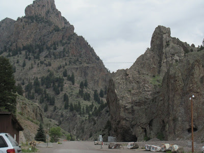
Looking through Wagon Wheel Gap.  In 1863 a group of prospectors abandoned a wagon as they were going through this gap.  Later, in the 1870s, a wagon wheel was found and believed to be from the previous Baker party.  Hence the name Wagon Wheel Gap.

One of the places to visit in the area is North Clear Creek Falls.  You can only view it from the top as there are no paths down to the bottom.

You can however walk out to the top of the falls and look down.

Standing on top of the falls looking back across to the viewing area.

Walking downstream you can see another large water diversion tunnel.  I wonder where this water is being piped?  The visitor center says the water from the Santa Maria Reservoir flows down Clear Creek and is diverted to the Rio Grande River for farm irrigation.

This little guy was clearly checking things out before heading out of his hole.

There are actually three different falls in the area.  This is the South Clear Creek Falls, where the trailhead is located in Silver Thread campground.

I think we were the only ones who found this falls.  Because I had incomplete information we missed the other falls and decided not to return on this day.  A few days later I did return and will post those pictures of Fisherman's Falls later.

The WINs gathering was located in a large meadow about 1/2 mile off the highway.  It was surrounded on three sides by hills and mountains.

Patty and Peter went fishing one afternoon and brought back this mess of fish.  Now to get Max to fry us up a fish fry....yum......

Wednesday, August 29, 2012

Lake City and Slumgullion Pass

We were told by several people, locals and travelers, that this was the place to go for cheeseburgers.  So of course since it was on our way to Lake City, Joyce and I had to stop.  Yes, they were good and I would recommend the place.  It is about 20 miles past Creede towards Lake City.

Looking towards Stony Pass.  In the foreground was the site of San Juan City, which now there aren't even traces.  Between 1871 and 1882 Stony Pass was the best route to Silverton.  It is now a 4-wheel drive route which I went over some 20 years ago.  Didn't make it this time, I don't have a 4-wheel drive and I don't think my HHR would make it.

More evidence of the trees turning.  I have never seen Aspen turn red, so when I was asking why, I was told the trees turning red were so dry from the drought they were dying and the red leaves were dying leave, not changing colors.  Too bad.  I love Aspens.

Some 850 years ago tons of earthen material broke off and slid some 4 miles down the mountain to form the Slumgullion Earthflow.  It blocked the Gunnison River and created San Cristobal Lake, the 2nd largest natural lake in Colorado.  They say the earth movement is still going on and this movement slides downhill about 20 feet per year.

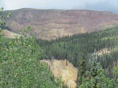
This is Red Mountain, aptly named because of its reddish color.

Overlooking Lake San Cristobal.  In 1874 gold was discovered in the river leading to the lake and the boom began.

A tribute to the victims of one of the most notorious scandals in Colorado.  Alfred Packer was a guide, leading five men from Salt Lake City to this area.  They became lost in a storm and Packer showed up later in the spring alone.  He claims the other men died naturally and then they ate the dead to survive, but when the remains of the others were found, it was discovered they had their heads bashed in.  Packer was captured and found guilty of murder and cannabalism.  He maintained his innocence until the day he died.

That is a cave in the side of the cliff.  I don't know if I would want a house built above that.  What if it caved in?

Lake City has made good use of the Packer story.  Here is the Packer Saloon and Cannibal Grill.

No, there's no ice and snow up here.  This is a picture I saw in the coffee shop.  You wouldn't fine me climbing that wall of ice.  That is a frozen waterfall outside of town.

And I didn't really see this either, just wished I had.  

After the big fire of 1879, most buildings were rebuilt using brick, such as this, the Blount Building, built in 1880.

Main Street, Lake City, is all of two blocks long, this is the other block.

Not really old, built in 1949, we wondered about the safety during the winter.  It looks like the snow could just avalanche down on top of the hotel.  I don't think I want to stay there except in the summer.

This church is old, established in 1891, and it reminds me of something you would see in Europe.  Very much of the gingerbread design.

Just kidding, I really didn't go over Engineer Pass.  The road is open for regular vehicles for the first nine miles or so.

About three miles up towards Engineer Pass is the Galena Mining area.  Long since deserted, there are lots of old buildings, mining equipment and this broken, earthen dam.

There was a strike by the miners in 1899 and the governor had the troops come out to keep the peace.  When it was all over, and an agreement had been reached, the Italian immigrant miners were told be gone in a week.  The ad which was placed for replacement miners politely stated "We can use about 75 men, Italians need not apply".

There are supposed to be both Elk and Moose in the area, but the only wildlife we saw were these deer, which were in town at Lake City.

Tuesday, August 28, 2012

Bachelor Loop and Creede

Creede, CO, is the only town in Mineral County.  It has a year round population of about 300, but swells to several thousand during the summer with all the people who travel hear for the hiking, atving and wonderful scenery and climate.
The fire department is now located inside the mountain in a cave.  It is a constant 50 degrees.

This is at the end of Main Street, and it is also the start of the Bachelor Loop.

The Creede Hotel, now a Bed and Breakfast and restaurant, it was built back in the late 1800s.  Creede was a mining town, and the population swelled to over 10,000 after silver was discovered in 1891.

The Creede Reporatory Theator is known beyond Creede.  They have a professional cast come every summer and provide broadway quality plays.

The Amethyst Vein is the largest in the Creede area.  It runs 4-10 feet wide for several miles and consistently assayed at over 200 ounces a ton, which was considered quite good.  The Bachelor Loop is a 17 mile dirt road which allows you to see the many mines which worked this vein. 

At the start of the loop are the remains of the Humphrey Mill, built in 1901.  At its height in 1904 it employed over 1,000 men.

The Commodore Mine, one of the first in the area, made by John C. Mackenzie and several of his friends. Here they discovered the famous Amethyst Vein.  This is one of the greatest silver mines and was operated from 1891 to 1976.  It has almost 200 miles of tunnels and underground workings.

The Commodore Ore House and Chutes.  Ore was loaded on wagons and taken to the railroad where it was transported to distant mills.  The Commodore did not use the Humphrey Mine.

Weaver Town site, where at one time several hundred people called this home.  Weaver City is located at the base of the richest producing mines, The Amethyst and Last Chance mines.

Looking beyond Weaver Town site to the Amethyst Mine and up on top of the hill is the Last Chance Mine (which I will visit more later).  The Amethyst Mine had 12 levels and at one time they produced 1500 ounces of silver per ton.

What is left of the Midwest Mine.  Although a vein was never found, they did find high grade ore.   No ore was ever shipped from this mine, even though it operated from 1911-1970.
  
The Equity Mine is still in operation today, although it was only in operation on and off from 1912-1970.  I believe it has started up operation again just recently.  The Equity Mine reopened in 2011.

With this snowcat they are prepared for the winter weather.  I understand it can get down to 20 degrees below 0.  Way too cold for my taste.

Just a sign that fall is on its way, some Aspen leaves have already changed to gold.

Looking down on the mines below from up above.

At the site of the Last Chance Mine, you can browse through old mining equipment, look at the extensive rocks for sale, wonder at the beautiful rings and jewelry for sale, or even go dig your own ore (for $2 a bucket).

Bachelor Town Site.  During the 1890s this town was larger than the current town of Creede (which at that time was called Jimtown) and did 2/3 of all business of the area.  

This deer watched us, but wasn't concerned enough to move.

There is no denying the beauty of the area.  This is looking down on Creede.

The Bulldog Mine is new (compared to all the old mines we viewed).  It was built  in 1969 and uses all modern mining and milling technology.

Bob Ford is no longer buried here, but he was.  Bob Ford is known as the man who shot Jesse James in the back.  After he shot Jesse, he headed west to avoid revenge from Jesse's friends.  It worked for several years and Bob Ford became a wealthy man by supplying liquor, cigars to the miners.  He eventually opened a saloon and gambling hall.  But a friend of Jesse's, Ed O'Kelly, came into the area and was elected sheriff of Bachelor City.  He heard that Bob Ford was running a saloon in Creede and went to check it out.  Two months later he confronted Bob Ford and shot him.  Bob Ford was well liked and his friends gathered a lynch mob to hang O'Kelly.  O'Kelly was saved from the lynch mob, but was convicted of the murder of Bob Ford and spent 10 years in prison.  Several months after Bob's death and burial here, his widow had his remains returned to Missouri, his home.