Friday, November 11, 2011

Leaving the Outer Banks

There are no pictures, this is simply my adventure of the day I left Avon, on the Outer Banks. The plan was simple, drive down to Cape Hatteras and board the free ferry to Ocrocoke Island. Spend the afternoon sightseeing and get in line for the first toll ferry to Cedar Point in the morning. Well, the best laid plans....

First, it was pouring rain and very windy the day we left. Max and I got our RVs on the free ferry and headed towards Ocrocoke Island. When we arrived at Ocrocoke Island we found the toll ferry to Cedar Point had been shut down due to high winds and seas and wasn't expected to be back in operation for a couple of days. No problem we thought, just wait it out on Ocrocoke and take the next toll ferry available in a couple of days. But that didn't happen. 

First we were told we could not park and sleep in our RVs while we waited, we would need to go to 1 of the 2 RV parks still open on the island. But when we got to the first park it was standing in water, and the other park wasn't much better. So we headed the 12 miles back across the island to the free ferry back to Cape Hatteras. It was 4pm, I didn't get to really visit Ocrocoke, the wild horses were undercover because of the rain, and I wasn't going to get to take the ferry over to Cedar Point. I had been driving in the wind and rain since 10:30 am, I was tired and I still had several more hours before I would be off the Outer Banks. 

But luckily nothing else of interest happened and by 7pm we were parked in Plymouth, NC. So much for simple plans......But I do love adventures and this day was definitely an adventure.

Outer Banks

On the way to Cape Hatteras we got to stop at Kitty Hawk, the place where Orville and Wilbur Wright flew the first airplane.
They have a sculpture made to the exact dimensions of the Wright Brothers plane which they flew on Dec 17, 1903.

 
These 4 stones represent the 4 flight from Dec 17, 1903. The first flight was just 12 seconds and went only 120 ft. But their final flight of the day (they crashed the plane) was still only 59 seconds and 852 feet. These were the first succesful, sustained powered flights and history was made.

It was quite windy most of the time we were down on the cape. This is where the eye of Hurricane Irene hit earlier this year.

 
These were some of the roughest seas I've seen on the Atlantic coast. They were like this every day we were there.

This temporary bridge had been open only 12 days when we crossed it on our way south on the outer banks. It took them about six weeks to open this highway following the hurricane. Before the hurricane there was no need for a bridge, but the hurricane created a new inlet when it rearranged the shore.

We saw lots of storm damage such as this broken concrete which had been a road.

We did have the opportunity to have a hot dog roast on the beach, even though it was quite windy.

Only 3 of us were willing to brave the wind and cool weather, Tom, Max and myself. You can see the rough seas in the background.

Max got caught in a wave while taking Fancy on the beach.

But a few minutes later so did I.

There was a fishing tournament going on. Lots of surf fisherman were out on the beach but we never saw anyone catching anything.


We did do more than just go to the beach, we went down to Cape Hatteras Point. The ring of blocks show where the original Cape Hatteras Lighthouse was located. Notice how close it is to the water. In 1870 it sat over 1500 feet away from high tide, but over the years the beach kept getting closer and closer until it threatened to wash away the lighthouse.

The current location of the Cape Hatteras lighthouse. Since the 1930s several attempts have been made to stop the erosion, but none were successful. It was determined in the 1980s to move the lighthouse after requesting advise from the Academy of Sciences. It was determined that moving the lighthouse was the best choice, but it would be a monumental job to move this 4,400 ton, 200 foot high lighthouse the recommended 2900 feet.

Contracts were awarded to International Chimney Company and Expert House Movers. There were many pictures and even video showing how they jacked up the lighthouse then placed it on rollers and roll beams to be moved. They started on June 17 and moving it along 5 feet at a time, placed it on its new location on July 9, 1999. Automatic sensors monitored every inch of the move.

We saw this funny silver cylindrical thing that looked like a space ship, and stopped to check it out. I don't know who was more scared, me or the alien.

This U.S. Weather Bureau Station was built in 1901 and was 1 of only 7 built specifically for weather observation. It served as a weather station until 1946.

At the tip of the cape, next to the ferry over to Ocracoke Island, was this small museum. It had been recommended so we stopped in to see. Glad we did, it had one of the best exhibits on pirates I have ever seen. The history of pirating, dating back to 3000 B.C., all the way to some info on current day pirates which operate mainly off the coast of Africa. Cape Hatteras is proud of their part in the history of Blackbeard. His favorite anchorage was Ocrocoke Inlet and after his pardon in June 1718, he settled in nearby Bath and some say married a local girl. But shortly he went back to pirating and found his end later that year in November 1718.


We also took a trip back up to Roanoke Island, site of mysterious disappearance of the Lost Colony in 1587.I loved this picture at the visitor center. Notice the serpent out in the ocean. It looks like it is going after one of the ships. And the island of Roanoke is behind the barrier islands. Even with all the searching over the past 300 years and all the archeological evidence, they still do not know what happened to the appx 115 colonists left behind when the ship sailed to England for supplies in 1587. When Governor John White returned in 1590 (he was delayed in England due to war), the colony was deserted with no real indication as to what happened. In that colony was the first American born child, Virginia Dare.

Bodie Island lighthouse. The visitor center was damaged in the hurricane and is not open. You can see some damage to the lighthouse as well.

I think Fancy would like to become a beach tramp. She loves to chase the birds on the beach and especially likes to mess with the dead horseshoe crabs.

Tuesday, November 8, 2011

Williamsburg, Yorktown, Jamestown and Ft. Monroe

We headed towards Hampton, north across the Chesapeake Bay, to visit Williamsburg, Jamestown and Yorktown. But right in Hampton was Ft. Monroe, so we headed there first.

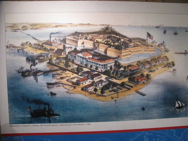
Ft. Monroe is the largest stone fort in the U.S. It was started in 1819, but wasn't finished until 1834. Robert E. Lee, later General of the Confederate Army, was one of the engineers who helped build Ft. Monroe.

Although Ft. Monroe sits at the end of Cape Comfort, surrounded by water on three sides, the fort was built inland a ways with a moat all the way around the fort. A busy port and supporting businesses and residences built up outside the fort in the 1800s. As you can see, the moat still exists.

This is one of the locations where Jefferson Davis, Confederate President, was held captive following the end of the Civil War. Another famous person who served at Ft. Monroe was Edgar Allen Poe. It is said his famous epic 'The Raven' was written based on his stay at Ft. Monroe. Ft. Monroe is also said to be haunted and TV shows have even come here to try and prove the ghosts really exist. Underneath the stone walls or casement, there is now a wonderful museum. I would recommend everyone visit Ft. Monroe

The current base commanders home. Until last year the base was an active army base. But recently the army reorganized and the base faced closure. The property was given back to the state of Virginia, who gave it to the city of Hampton. Although the base is no longer active, most of the housing is still occupied by military familes from surrounding areas. Some families are awaiting their loved ones to return from overseas. But by next year the military should be moved out and the city plans on making this affordable housing. There is also a move to take some of the old buildings inside the stone fort and making a high school.
More of the housing located outside the stone fort on Ft. Monroe. In the background is a large building which used to be a hotel, then the military used it for offices. It has recently been updated and remodeled into senior housing. I was told it cost $3000 a month for an apartment.

 Another bit of history for Cape Comfort. In the early to mid 1600s, this area was a port where slavers brought in new slaves from Africa. During the Civil War Ft. Monroe was occupied by the Union and this area was considered a safe-haven for escaping slaves. During the Civil War and immediately following there was a thriving black community, including schools to teach the recently freed slaves how to read and write.

 
The next day it was raining, but we decided to get out anyway. We headed toward Yorktown, where British Commander Cornwallis surrendered to General George Washington. This was one of the last major battles of the Revolutionary War.

The memorial sits on top of the hill in Yorktown, overlooking the York River and the battlefields nearby. George Washington, along with French Leader Rochambeau, Washington's aide, Lafayette, and about 15000 troops, confronted the British. French Naval Captain De Grasse was instrumental in blockading the harbor, keeping Cornwallis from receiving more British aide and supplies.

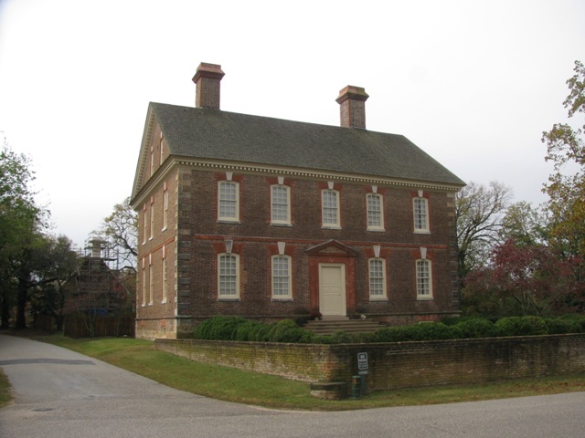
The Nelson house withstood the shelling of the Revolutionary War as well as the burning of the Civil War.

There are several cannonballs imbedded in the side of the house.

The Moore house, located outside of town, is where the officers came to meet face-to-face to discuss the British surrender terms.

The next day was bright and clear, but cold. Just the day to visit Williamsburg and Jamestown.

The governor's mansion in Williamsburg. This is the place where George Washington met his future wife, Martha.

Bruxton Parish Church has been in operation continuously since 1715. It is one of the oldest Episcipal churches in the U.S.

It was only about 45 degrees. Even Fancy had her coat on.

As you walked around Historic Williamsburg you got a glimpse of what it might have been like back in the 1700s. Historic Williamsburg was the brainchild of John D. Rockefeller Jr. He wanted to restore, recreate and preserve our history and our past.

We ran across this unusual instrument. It is played by winding the handle on the end. It turns a wheel across the strings. But even though it is a stringed instrument, it has the sound of bagpipes. Very pretty. I recorded it, but the file is very large. If I can get it reduced, I'll post it in another blog.

The capital building restored. Williamsburg was the first capital of Virginia. The capital was later moved to Richmond after the Revolutionary War.

The College of William and Mary is located is Williamsburg. Except for Harvard, it is the oldest college in America, founded in 1693, chartered by King William and Queen Mary.

The original college building, built in 1693, is now the college president's office.
After wandering through Historic Williamsburg, we decided to head towards Jamestown.

The restored church is built upon the foundations of the the first church of Jamestown, built in 1617. 104 men and boys landed at Jamestown in 1607. Over the next few years more settlers came, but between Indian problems and lack of food and disease, only about 60 of the 600 who came to Jamestown survived. By 1610 though, the settlement stabilized and eventually became a thriving port throughout the 1600s. In the late 1600s the settlement of Williamsburg became more important and was the eventual demise of Jamestown. By the early 1700s the town was no more, and only a few plantations remained.

Although this looks like the ruins of old foundations, they are actually reconstructed ruins. The original ruins were discovered and verified and studied by archeologists, then covered up again for preservation. Then these reconstructed ruins were built on the exact sites of the original ruins. (did you get all that? I'm not sure I did)

The Ambler Plantation. I don't know if these are again, reconstructed ruins or the original ruins. But this plantation house really wasn't all that large, not like the plantation houses you see in the movies.

These deer were wandering around the area. They not only were not afraid of us, but they weren't even afraid of Fancy.

Well, enough history for a while, now its off the the beach again. Outer Banks here we come.

Monday, October 31, 2011

Portsmouth, Virginia Beach and Norfolk, VA

We arrived at the Portsmouth Moose Lodge, where they have a pool. I don't think they have used this pool in a long, long time.

At the lookout for the Chesapeake Bay Bridge/Tunnel, Fancy tried to make friends with this little crab. No, she didn't get her nose pinched and Max was able to convince the little crab it would be better off next to the shore and not up in the parking lot.

Norfolk Naval Base is the largest naval base in the world with over 54,000 personnel. They give tours and even allowed a few pictures.

Two aircraft carriers were in port, the USS Eisenhower and the USS Enterprise. Several other ships were also in port as well. Five of the 12 aircraft carriers call Norfolk Naval Base their home.

They also had quite a contingent of helicopters based here as well.

The Navy's version of the Airborne Warning and Control aircraft.

This home is base housing for one of the many generals assigned to this base. It is one of many buildings built in the early 1900s for a world's fair held at this site.

In old downtown Norfolk you will find some interesting architecture, like this old church.

But this is not a church anymore, but a restaurant, where we had a wonderful lunch. It was once an abbey, hence the name Freemason Abbey Restaurant.

Norfolk is also home to the largest naval shipyard in the world. Here are two supply ships under retrofit.

In Old Portsmouth the streets are lined with older homes like this. Most have now been turned into apartments and condos. Portsmouth has a history in both the Revolutionary War and the Civil War. Most of these homes actually date from the 1830s or newer since much of the town was burnt to the ground during the Revolutionary War.

You can't come to this area without visiting Virginia Beach. It was quiet and most things were closed since the season is over.

This former Life Saving Station now sits in the middle of high rise hotels and condo's on the boardwalk in Virginia Beach.

Neptune stands tall on the boardwalk.

One of the most prestegious hotels in Virginia Beach.

At the end of the point, on Fort Story which is an active base, is Cape Henry lighthouse, built in 1792.

It has now been replaced with this lighthouse, located across the street.

Memorial to Francois Joseph Paul de Grasse, captain of the French Fleet which stopped the English Fleet from rescuing British General Cornwallis. This allowed American General George Washington to defeat Cornwallis at Yorktown, effectively ending the American Revolution.

Memorial for all the colonists who first stepped foot on American soil in 1607. They landed first at Cape Henry before settling at Jamestown.